- Industry Size (2026)
- USD 5.5 Bn
- Forecast (2036)
- USD 18.4 Bn
- CAGR (2026 to 2036)
- 12.9%
Aerial Imaging Market Forecast and Outlook 2026 to 2036
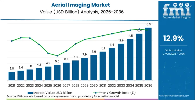
The global aerial imaging sector is on track to achieve a valuation of USD 18.4 billion by 2036, accelerating from USD 5.5 billion in 2026 at a CAGR of 12.9%. As per Future Market Insights, expansion is structurally underpinned by the global proliferation of commercial drone operations, the integration of AI-powered image analysis into geospatial workflows, and the growing demand for NDAA-compliant aerial intelligence from government and defence agencies.
The Federal Aviation Administration (FAA) reported in its 2024 Aerospace Forecast that the US commercial drone fleet is projected to grow to 955,000 units by 2028, validating the operational platform base that drives aerial imaging demand. This fleet growth compels aerial imaging companies to invest in AI-powered SAR analysis, autonomous swarm coordination, and vertically integrated Drone-as-a-Service delivery models. Simultaneously the defence sector is accelerating procurement of counter-UAS imaging capabilities and AI-driven autonomous intercept systems.
In February 2026, Fortem Technologies successfully demonstrated an autonomous 5-vs-5 drone swarm intercept using its SkyDome platform, coordinating five interceptors with no human involvement. FMI is of the opinion that autonomous drone swarm imaging and intercept capabilities will capture 20 to 25% of the defence aerial intelligence market by 2030, as military procurement shifts from manned ISR platforms to autonomous, AI-coordinated swarm architectures.
The competitive landscape in 2025 and 2026 is defined by autonomous swarm technology, DaaS consolidation, and AI-SAR partnerships. ICEYE and SATIM signed a partnership in February 2025 for joint development of AI-powered SAR imagery analysis for vessel and aircraft detection. Drone Forge and Airbus signed a Letter of Intent in March 2025 for Flexrotor uncrewed aerial system deployment in Asia. XTI Aerospace announced projected 30% revenue growth for 2026 targeting over USD 160 million, pivoting toward NDAA-compliant US-based drone solutions.
ZenaTech completed a trio of acquisitions in January 2026 as part of a 19-company DaaS acquisition spree in 2025 for vertically integrated imaging in construction, forestry, and mining. NVIDIA and Nokia established a strategic partnership in October 2025 for AI-native mobile networks supporting aerial data transmission. As per FMI, this convergence of autonomous swarm intercept, AI-SAR analysis, and DaaS vertical integration confirms that aerial imaging is transitioning from a project-based capture service into a persistent, AI-driven geospatial intelligence subscription platform.
Summary of Aerial Imaging Market
What Is Growth Outlook for Aerial Imaging Market as per Future Market Insights Projection?
Future Market Insights projects the aerial imaging industry to expand at a CAGR of 12.9% from 2026 to 2036, increasing from USD 5.5 Billion in 2026 to USD 18.4 Billion by 2036.
FMI Research Approach: FMI proprietary forecasting model based on FAA drone fleet projections, defence ISR procurement budgets, and DaaS revenue model analysis.
How Do FMI Analysts Perceive Aerial Imaging Market to Evolve?
FMI analysts perceive the market evolving toward persistent, AI-driven geospatial intelligence platforms where autonomous drone swarms replace project-based manned aircraft missions and DaaS subscription models replace one-time data purchases.
FMI Research Approach: FAA 2024 Aerospace Forecast and Fortem Technologies swarm demonstration analysis.
Which Country Holds Largest Share in Global Aerial Imaging Market?
The United States holds a significant share of the global aerial imaging market by value which is supported by FAA commercial drone fleet scale, defence ISR procurement budgets, and the concentration of AI-powered aerial imaging companies.
FMI Research Approach: FMI country-level revenue modeling by FAA drone registration data and DoD ISR procurement budgets.
How Large Will Aerial Imaging Market Be by 2036?
The global aerial imaging market is projected to reach USD 18.4 Billion by 2036.
FMI Research Approach: FMI long-term revenue forecast derived from commercial drone fleet growth projections and defence ISR modernisation budgets.
What Is Definition of Aerial Imaging Market?
The aerial imaging market includes drone-based imagery, satellite imaging, manned aircraft photography, AI-powered SAR analysis, LiDAR scanning, and geospatial data processing services used across defence, agriculture, infrastructure, mining, construction, and environmental monitoring applications.
FMI Research Approach: FMI market taxonomy aligned with FAA UAS classification and defence ISR procurement categories.
What Are Globally Unique Trends Shaping Aerial Imaging Market?
Globally unique trends include autonomous 5-vs-5 drone swarm intercept (Fortem SkyDome), AI-powered SAR vessel detection partnerships (ICEYE/SATIM), and 19-company DaaS consolidation sprees for vertically integrated imaging (ZenaTech).
FMI Research Approach: Fortem Technologies demonstration tracking and ZenaTech DaaS acquisition analysis.
Aerial Imaging Market Key Takeaways
| Metric | Details |
|---|---|
| Industry Size (2026) | USD 5.5 Billion |
| Industry Value (2036) | USD 18.4 Billion |
| CAGR (2026 to 2036) | 12.9% |
Source: Future Market Insights (FMI) analysis, based on proprietary forecasting model and primary research
Semi-Annual Market Update
The below table presents the expected CAGR for the global aerial imaging market over several semi-annual periods spanning from 2026 to 2036. This assessment outlines changes in the Aerial Imaging industry and identify revenue trends, offering key decision makers an understanding about market performance throughout the year.
H1 represents first half of the year from January to June, H2 spans from July to December, which is the second half. In the first half (H1) of the year from 2025 to 2035, the business is predicted to surge at a CAGR of 12.8%, followed by a slightly higher growth rate of 13.2% in the second half (H2) of the same decade.
| Particular | Value CAGR |
|---|---|
| H1 2025 | 12.8% (2025 to 2035) |
| H2 2025 | 13.2% (2025 to 2035) |
| H1 2026 | 12.6% (2026 to 2036) |
| H2 2026 | 13.5% (2026 to 2036) |
Moving into the subsequent period, from H1 2025 to H2 2035, the CAGR is projected to decrease slightly to 12.6% in the first half and remain higher at 13.5% in the second half. In the first half (H1) the market witnessed a decrease of 20 BPS while in the second half (H2), the market witnessed an increase of 30 BPS.
Key Industry Highlights
Increasing demand for high-resolution imaging and thermal capabilities is fueling the growth
The High-resolution imaging provided by advanced HD and thermal cameras helps to offers unparalleled detail and clarity in aerial data which is very vital for applications in security, defense, urban planning and environmental monitoring. According to Department of Homeland Security USA increased funding for surveillance technology.
The support highlights the critical role of high-resolution imaging in national security and public safety. In 2024, DJI launched its Mavic 3 Enterprise series to enhanced flight capabilities. The new line will grow rapidly and the adoption over 10,000 units across commercial and governmental sectors within the first quarter of release.
Rising use of Thermal Imaging Cameras in security and defense for advanced surveillance
The thermal imaging technology helps to detect heat signatures rather than visible light and help to offers significant advantages in low-light and challenging environmental conditions. The capability is particularly valuable for security and defense operations for detecting intrusions, monitoring borders and ensuring situational awareness are critical. In 2024, Department of Defense allocated USD 50 million to integrate advanced thermal imaging systems into drone platforms for border surveillance and tactical operations in USA The investment focused on increasing importance of thermal cameras in national security strategies.
The thermal imaging segment is expected to grow at a CAGR 14% in next five years due to security needs and advancements in thermal technology. The growth reflects the vital role thermal imaging plays in modern surveillance and defense applications.
Increasing use of UAVs/Drones in agriculture and disaster management for real-time data collection
The drones are equipped with high-resolution cameras and sensors is used for monitoring crop health, to optimize irrigation and assess soil conditions in agriculture. The technology allows for precise, data-driven decisions help to improve yield and to reduce resource usage. According to Department of Agriculture allocated USD 20 million to deploy drones around 10,000 farms for monitoring crop performance and help to streamline farming practices.
The Federal Emergency Management Agency allocated USD 15 million for integrating drones into disaster response toolkit. The funding helps to supports the acquisition of UAVs for deployment during natural disasters and emergencies.
Increasing concerns over data privacy and security issues hinder the deployment of aerial imaging technologies
The drones and aerial imaging systems capture large amounts of data such as sensitive information about individuals and properties, the risk of data breaches and unauthorized access becomes a critical issue. The use of high-resolution cameras and thermal imaging will unintentionally capture private or confidential information and it will raise fears of surveillance overreach and misuse.
Governments and regulatory bodies help for analyzing how aerial data is collected, stored and shared and it will lead to stricter compliance requirements and potential legal complications for vendors operating in this space. The privacy concerns will delay project approvals, complicate the deployment process and increase operational costs.
2021 to 2025 Global Aerial Imaging Sales Outlook Compared to Demand Forecasts from 2026 to 2036
The aerial imaging market globally experienced steady growth due to increased adoption across different sectors such as agriculture, infrastructure and defense. The global sales of UAVs and imaging systems saw a prominent rise and grows at 10.2% during 2021 to 2025. In 2024, the global sales of aerial imaging reached 4,300.0 Million and it is reflecting a demand for high-resolution and thermal imaging capabilities.
Looking forward, from the period 2026 to 2036 suggest an accelerated growth. The market is anticipated to expand significantly grows at a CAGR of 12.9%. In 2025, the market for aerial imaging systems is estimated 4,854.7 Million in 2025 and reach by 2035 16,334.3 Million. The forecast highlights the rising dependence on aerial imaging for real-time data collection and decision-making in different industries.
Market Concentration
Tier 1 vendors dominating the global aerial imaging market with a significant share propelled by their advanced technology and broad market reach. The major giants in this category such as DJI, Parrot and FLIR Systems. Tier 1 contributing around 40% to 45% of the global market share.
Tier 2 vendors contain presence but with a smaller share compared to Tier 1. The company’s focus on niche markets or specialized applications. The key players such as Yuneec International, senseFly and Delair and cater around 15-% to 20% of the market.
Tier 3 vendors include smaller in market presence and it is catering to specific segments or emerging needs in the industry. Tier 3 vendors include Quantum Systems, Skycatch and Wingtra. The companies typically cater around 30% to 35% of the market and are known for their innovative approaches or localized solutions.
Country-wise Insights
The section highlights the CAGRs of countries experiencing growth in the Aerial Imaging market, along with the latest advancements contributing to overall market development. Based on current estimates China, India and Germany market are expected to see steady growth during the forecast period.
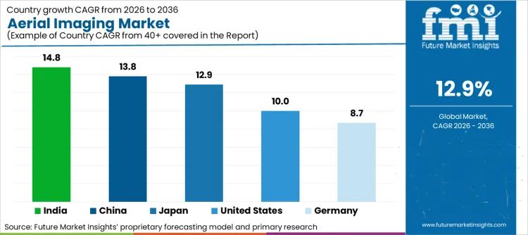
| Countries | CAGR from 2026 to 2036 |
|---|---|
| India | 14.8% |
| China | 13.8% |
| Germany | 8.7% |
| Japan | 12.9% |
| United States | 10.0% |
India's Defense & Security Intelligence sector is adopting drones for border surveillance and national security
The government of India is focused on investment in aerial imaging technologies to secure its borders such as in sensitive areas like northern and western regions. In 2024, the Ministry of Defense allocated USD 600 million to boost surveillance infrastructure such as UAVs equipped with thermal and HD cameras.
In 2022, IdeaForge partnered with Indian Army to supply high-end surveillance drones, while Bharat Electronics Limited secured a major contract to provide advanced UAVs for intelligence operations for India aerial surveillance capabilities. The drone market in India is projected to grow at a CAGR of 16% through 2028. India is anticipated to see substantial growth at a CAGR 14.8% from 2026 to 2036 in the Aerial Imaging market.
Disaster & Response Management in the USA is progressively depended on UAVs for real-time data collection during natural disasters
The ability of drones for providing aerial imagery and thermal data has transformed how authorities respond to wildfires, hurricanes, floods and other crises. In 2020, The wildfires in California, drones equipped with thermal imaging cameras helped firefighters to assess the intensity of the flames and helps to locate hotspots for improvement in response times and for reducing risks.
The Federal Emergency Management Agency is integrated UAVs into disaster management protocols for utilizing drones to survey damage, to assess infrastructure and monitor recovery efforts. In 2022, FEMA allocated USD 35 million for improvement in drone technology and disaster response. USA Aerial Imaging market is anticipated to grow at a CAGR 10.0% during this period.
China rapid urbanization propels the demand for Geospatial Mapping and Urban Planning & Development using advanced aerial imaging technologies
The urban areas focused on expansion and new cities are developed there is a rising need for accurate and up-to-date geospatial data to support planning and infrastructure projects. In 2022, China Ministry of Natural Resources allocated USD 2 billion project to boost geospatial data infrastructure. It involves advanced drones with high-resolution cameras for city planning and land mapping.
The geospatial imaging market in China is estimated to grow at a CAGR of 15% through 2028 with the urban planning segment accounts 40% of this growth. China is anticipated to see substantial growth in the Aerial Imaging market significantly holds dominant share of 52.9% in 2026.
Category-wise Insights
The section provides detailed insights into key segments of the Aerial Imaging market. The component category includes hardware, software and services. Industry category such as Government, Military & Defense, Agriculture & Forestry, Energy & Mining, Media & Entertainment, Construction & Engineering and Others. Among these, services are growing quickly. The Government hold largest market share in Aerial Imaging market.
Surge in Aerial Imaging & Mapping Services Propel by Rising Demand for Detailed Geospatial Data in Urban Planning and Infrastructure Development
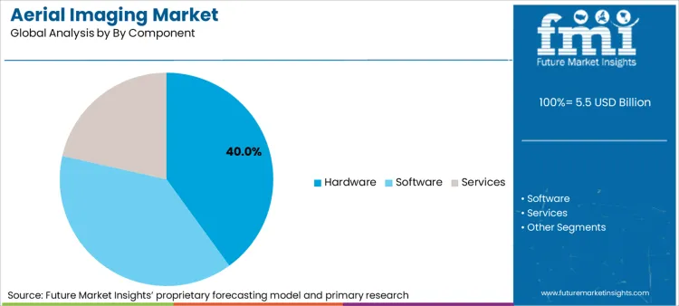
Governments worldwide are recognizing the value of aerial imaging for creating precise maps and models which are very crucial for efficient city planning and infrastructure management. According to government of Brazil initiative Smart Cities Brazil project allocated USD 1.5 billion to integrate aerial imaging technology into urban development plans.
The initiative will help the drones to use for mapping and infrastructure monitoring in major cities. In 2023, South Africa allocated USD 500 Million for the Geospatial Mapping Initiative to deploy drones for improvement in land use planning and environmental monitoring. Services is anticipated to see substantial growth at a CAGR 14.6% from 2025 to 2035 in the Aerial Imaging market.
| Segment | CAGR (2025 to 2035) |
|---|---|
| Services (Component) | 14.6% |
Government Sector Dominates Aerial Imaging Market Due to Extensive Use in Security, Surveillance and Infrastructure Monitoring
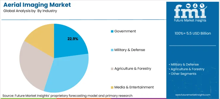
The government sector holds the dominating share due to its extensive use in security, surveillance and infrastructure monitoring. Governments are focused on heavy investment in aerial imaging technologies to enhance national security, to manage urban infrastructure and respond to natural disasters.
In 2023, According to South Korea initiative such as Smart City Drone Program received USD 800 million investment from the government to integrate drones into urban infrastructure planning and disaster management. The program helps to enhance the precision of geospatial data for planning and emergency response. Government is projected to dominate the Aerial Imaging market, capturing a substantial share of 22.9% in 2024.
| Segment | Value Share (2025) |
|---|---|
| Government (Industry) | 22.9% |
Competition Outlook
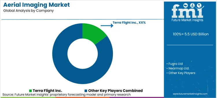
The aerial imaging market is highly competitive with various players focused on technologies. Vendors are enhancing offerings through partnerships and innovations. Key areas of competition include advancements in AI-driven insights, improvements in aerial surveying accuracy and enhancements in imaging quality. The competitive environment propels rapid technological progress and specialization across various applications in the market.
Recent Developments
- In February 2026, Fortem Technologies demonstrated an autonomous 5-vs-5 drone swarm intercept using its SkyDome AI platform with zero human involvement.
- In February 2025, ICEYE and SATIM signed a partnership for AI-powered SAR imagery analysis products for vessel and aircraft detection.
- In January 2026, ZenaTech completed a trio of acquisitions as part of its 19-company DaaS expansion spree for vertically integrated imaging in construction, forestry, and mining.
Key players in the Aerial Imaging Industry
- Terra Flight Aerial Imaging Inc.
- Fugro Ltd
- Nearmap Ltd.
- Eagle View Technologies, Inc.
- Digital Aerial Solutions, LLC
- Aerial Imaging Productions, LLC
- Cooper Aerial Surveys Co.
- Landiscor Real Estate Mapping
- Kucera International Inc.
- GeoVantage, Inc. (Aeroptic, LLC)
Market Definition
The aerial imaging market represents revenue generated from the capture, processing, and delivery of imagery and geospatial data from aerial platforms. The market measures the value of drone imaging services, satellite imagery subscriptions, manned aircraft photography, AI-powered image analysis, LiDAR data, and integrated DaaS platforms sold to government, defence, commercial, and industrial customers.
Inclusions cover commercial drone imaging (RGB, multispectral, thermal, LiDAR), satellite optical and SAR imagery, manned aircraft aerial photography, AI-powered image analysis and classification software, counter-UAS imaging and intercept systems, and Drone-as-a-Service subscription platforms for construction, agriculture, mining, and infrastructure inspection.
Exclusions include satellite manufacturing and launch services (covered separately), consumer recreational drone photography, standalone GIS software without aerial data integration, and ground-based remote sensing systems.
Scope of Report
| Items | Values |
|---|---|
| Quantitative Units (2026) | USD 5.5 Billion |
| Product Type | Drone Imaging, Satellite Imagery, Manned Aircraft, AI-SAR Analysis, LiDAR, Counter-UAS Imaging, DaaS Platforms |
| End User | Defence/Government, Agriculture, Construction, Mining, Infrastructure, Environmental |
| Regions Covered | North America, Europe, Asia Pacific, Latin America, Middle East and Africa |
| Countries Covered | USA, Finland, Australia, Israel, India, and 40+ countries |
| Key Companies Profiled | ICEYE, Fortem Technologies, XTI Aerospace, ZenaTech, Airbus, NVIDIA |
Aerial Imaging Market Segmentation
By Component:
In terms of component, the segment is divided into hardware, software and services.
By Application:
In terms of application, the segment is segregated into Defense & Security Intelligence, Geospatial Mapping, Urban Planning & Development, Disaster & Response Management, Energy & Natural Resource Management and Others.
By Industry:
In terms of industry, the segment is segregated into Government, Military & Defense, Agriculture & Forestry, Energy & Mining, Media & Entertainment, Construction & Engineering and Others.
By Region:
A regional analysis has been carried out in key countries of North America, Latin America, East Asia, South Asia & Pacific, Western Europe, Eastern Europe and Middle East and Africa (MEA), and Europe.
Bibliography
- Federal Aviation Administration. (2024). FAA Aerospace Forecast 2024: US Commercial Drone Fleet Projections. FAA.
- Fortem Technologies. (2026, February). Autonomous 5-vs-5 drone swarm intercept demonstration. Fortem Technologies.
- ICEYE. (2025, February). ICEYE and SATIM AI-powered SAR analysis partnership announcement. PR Newswire.
- ZenaTech Inc. (2026, January). DaaS acquisition completion for construction and mining imaging. ZenaTech.
Frequently Asked Questions
What is the current global market size for Aerial Imaging?
The global market is valued at USD 5.5 Billion in 2026, driven by commercial drone fleet growth, AI-SAR analysis, and defence autonomous swarm procurement.
What is the projected CAGR for the market over the next 10 years?
The market is projected to grow at a CAGR of 12.9% from 2026 to 2036.
Which regions are experiencing the fastest expansion?
Asia Pacific is the fastest-growing region driven by infrastructure and agricultural imaging demand, while North America leads by value through defence ISR procurement and commercial drone fleet scale.
What are the primary market drivers?
Commercial drone fleet proliferation, AI-powered SAR analysis, autonomous swarm intercept technology, and DaaS subscription model adoption are the primary growth catalysts.
Who are the leading suppliers in the industry?
ICEYE, Fortem Technologies, ZenaTech, and Airbus are key players, differentiating through SAR satellite imaging, autonomous swarm capability, and DaaS vertical integration.
Preview the report firsthand - request a free sample
Get SampleGet the brochure for pricing and purchase details.
Get PDFTable of Content
- Executive Summary
- Global Market Outlook
- Demand-side Trends
- Supply-side Trends
- Technology Roadmap Analysis
- Analysis and Recommendations
- Market Overview
- Market Coverage / Taxonomy
- Market Definition / Scope / Limitations
- Research Methodology
- Chapter Orientation
- Analytical Lens and Working Hypotheses
- Market Structure, Signals, and Trend Drivers
- Benchmarking and Cross-market Comparability
- Market Sizing, Forecasting, and Opportunity Mapping
- Research Design and Evidence Framework
- Desk Research Programme (Secondary Evidence)
- Company Annual and Sustainability Reports
- Peer-reviewed Journals and Academic Literature
- Corporate Websites, Product Literature, and Technical Notes
- Earnings Decks and Investor Briefings
- Statutory Filings and Regulatory Disclosures
- Technical White Papers and Standards Notes
- Trade Journals, Industry Magazines, and Analyst Briefs
- Conference Proceedings, Webinars, and Seminar Materials
- Government Statistics Portals and Public Data Releases
- Press Releases and Reputable Media Coverage
- Specialist Newsletters and Curated Briefings
- Sector Databases and Reference Repositories
- FMI Internal Proprietary Databases and Historical Market Datasets
- Subscription Datasets and Paid Sources
- Social Channels, Communities, and Digital Listening Inputs
- Additional Desk Sources
- Expert Input and Fieldwork (Primary Evidence)
- Primary Modes
- Qualitative Interviews and Expert Elicitation
- Quantitative Surveys and Structured Data Capture
- Blended Approach
- Why Primary Evidence is Used
- Field Techniques
- Interviews
- Surveys
- Focus Groups
- Observational and In-context Research
- Social and Community Interactions
- Stakeholder Universe Engaged
- C-suite Leaders
- Board Members
- Presidents and Vice Presidents
- R&D and Innovation Heads
- Technical Specialists
- Domain Subject-matter Experts
- Scientists
- Physicians and Other Healthcare Professionals
- Governance, Ethics, and Data Stewardship
- Research Ethics
- Data Integrity and Handling
- Primary Modes
- Tooling, Models, and Reference Databases
- Desk Research Programme (Secondary Evidence)
- Data Engineering and Model Build
- Data Acquisition and Ingestion
- Cleaning, Normalisation, and Verification
- Synthesis, Triangulation, and Analysis
- Quality Assurance and Audit Trail
- Market Background
- Market Dynamics
- Drivers
- Restraints
- Opportunity
- Trends
- Scenario Forecast
- Demand in Optimistic Scenario
- Demand in Likely Scenario
- Demand in Conservative Scenario
- Opportunity Map Analysis
- Product Life Cycle Analysis
- Supply Chain Analysis
- Investment Feasibility Matrix
- Value Chain Analysis
- PESTLE and Porter’s Analysis
- Regulatory Landscape
- Regional Parent Market Outlook
- Production and Consumption Statistics
- Import and Export Statistics
- Market Dynamics
- Global Market Analysis 2021 to 2025 and Forecast, 2026 to 2036
- Historical Market Size Value (USD Million) Analysis, 2021 to 2025
- Current and Future Market Size Value (USD Million) Projections, 2026 to 2036
- Y-o-Y Growth Trend Analysis
- Absolute $ Opportunity Analysis
- Global Market Pricing Analysis 2021 to 2025 and Forecast 2026 to 2036
- Global Market Analysis 2021 to 2025 and Forecast 2026 to 2036, By By Industry
- Introduction / Key Findings
- Historical Market Size Value (USD Million) Analysis By By Industry , 2021 to 2025
- Current and Future Market Size Value (USD Million) Analysis and Forecast By By Industry , 2026 to 2036
- Government
- Military & Defense
- Agriculture & Forestry
- Media & Entertainment
- Government
- Y-o-Y Growth Trend Analysis By By Industry , 2021 to 2025
- Absolute $ Opportunity Analysis By By Industry , 2026 to 2036
- Global Market Analysis 2021 to 2025 and Forecast 2026 to 2036, By By Component
- Introduction / Key Findings
- Historical Market Size Value (USD Million) Analysis By By Component, 2021 to 2025
- Current and Future Market Size Value (USD Million) Analysis and Forecast By By Component, 2026 to 2036
- Hardware
- Software
- Services
- Hardware
- Y-o-Y Growth Trend Analysis By By Component, 2021 to 2025
- Absolute $ Opportunity Analysis By By Component, 2026 to 2036
- Global Market Analysis 2021 to 2025 and Forecast 2026 to 2036, By Region
- Introduction
- Historical Market Size Value (USD Million) Analysis By Region, 2021 to 2025
- Current Market Size Value (USD Million) Analysis and Forecast By Region, 2026 to 2036
- North America
- Latin America
- Western Europe
- Eastern Europe
- East Asia
- South Asia and Pacific
- Middle East & Africa
- Market Attractiveness Analysis By Region
- North America Market Analysis 2021 to 2025 and Forecast 2026 to 2036, By Country
- Historical Market Size Value (USD Million) Trend Analysis By Market Taxonomy, 2021 to 2025
- Market Size Value (USD Million) Forecast By Market Taxonomy, 2026 to 2036
- By Country
- USA
- Canada
- Mexico
- By By Industry
- By By Component
- By Country
- Market Attractiveness Analysis
- By Country
- By By Industry
- By By Component
- Key Takeaways
- Latin America Market Analysis 2021 to 2025 and Forecast 2026 to 2036, By Country
- Historical Market Size Value (USD Million) Trend Analysis By Market Taxonomy, 2021 to 2025
- Market Size Value (USD Million) Forecast By Market Taxonomy, 2026 to 2036
- By Country
- Brazil
- Chile
- Rest of Latin America
- By By Industry
- By By Component
- By Country
- Market Attractiveness Analysis
- By Country
- By By Industry
- By By Component
- Key Takeaways
- Western Europe Market Analysis 2021 to 2025 and Forecast 2026 to 2036, By Country
- Historical Market Size Value (USD Million) Trend Analysis By Market Taxonomy, 2021 to 2025
- Market Size Value (USD Million) Forecast By Market Taxonomy, 2026 to 2036
- By Country
- Germany
- UK
- Italy
- Spain
- France
- Nordic
- BENELUX
- Rest of Western Europe
- By By Industry
- By By Component
- By Country
- Market Attractiveness Analysis
- By Country
- By By Industry
- By By Component
- Key Takeaways
- Eastern Europe Market Analysis 2021 to 2025 and Forecast 2026 to 2036, By Country
- Historical Market Size Value (USD Million) Trend Analysis By Market Taxonomy, 2021 to 2025
- Market Size Value (USD Million) Forecast By Market Taxonomy, 2026 to 2036
- By Country
- Russia
- Poland
- Hungary
- Balkan & Baltic
- Rest of Eastern Europe
- By By Industry
- By By Component
- By Country
- Market Attractiveness Analysis
- By Country
- By By Industry
- By By Component
- Key Takeaways
- East Asia Market Analysis 2021 to 2025 and Forecast 2026 to 2036, By Country
- Historical Market Size Value (USD Million) Trend Analysis By Market Taxonomy, 2021 to 2025
- Market Size Value (USD Million) Forecast By Market Taxonomy, 2026 to 2036
- By Country
- China
- Japan
- South Korea
- By By Industry
- By By Component
- By Country
- Market Attractiveness Analysis
- By Country
- By By Industry
- By By Component
- Key Takeaways
- South Asia and Pacific Market Analysis 2021 to 2025 and Forecast 2026 to 2036, By Country
- Historical Market Size Value (USD Million) Trend Analysis By Market Taxonomy, 2021 to 2025
- Market Size Value (USD Million) Forecast By Market Taxonomy, 2026 to 2036
- By Country
- India
- ASEAN
- Australia & New Zealand
- Rest of South Asia and Pacific
- By By Industry
- By By Component
- By Country
- Market Attractiveness Analysis
- By Country
- By By Industry
- By By Component
- Key Takeaways
- Middle East & Africa Market Analysis 2021 to 2025 and Forecast 2026 to 2036, By Country
- Historical Market Size Value (USD Million) Trend Analysis By Market Taxonomy, 2021 to 2025
- Market Size Value (USD Million) Forecast By Market Taxonomy, 2026 to 2036
- By Country
- Kingdom of Saudi Arabia
- Other GCC Countries
- Turkiye
- South Africa
- Other African Union
- Rest of Middle East & Africa
- By By Industry
- By By Component
- By Country
- Market Attractiveness Analysis
- By Country
- By By Industry
- By By Component
- Key Takeaways
- Key Countries Market Analysis
- USA
- Pricing Analysis
- Market Share Analysis, 2025
- By By Industry
- By By Component
- Canada
- Pricing Analysis
- Market Share Analysis, 2025
- By By Industry
- By By Component
- Mexico
- Pricing Analysis
- Market Share Analysis, 2025
- By By Industry
- By By Component
- Brazil
- Pricing Analysis
- Market Share Analysis, 2025
- By By Industry
- By By Component
- Chile
- Pricing Analysis
- Market Share Analysis, 2025
- By By Industry
- By By Component
- Germany
- Pricing Analysis
- Market Share Analysis, 2025
- By By Industry
- By By Component
- UK
- Pricing Analysis
- Market Share Analysis, 2025
- By By Industry
- By By Component
- Italy
- Pricing Analysis
- Market Share Analysis, 2025
- By By Industry
- By By Component
- Spain
- Pricing Analysis
- Market Share Analysis, 2025
- By By Industry
- By By Component
- France
- Pricing Analysis
- Market Share Analysis, 2025
- By By Industry
- By By Component
- India
- Pricing Analysis
- Market Share Analysis, 2025
- By By Industry
- By By Component
- ASEAN
- Pricing Analysis
- Market Share Analysis, 2025
- By By Industry
- By By Component
- Australia & New Zealand
- Pricing Analysis
- Market Share Analysis, 2025
- By By Industry
- By By Component
- China
- Pricing Analysis
- Market Share Analysis, 2025
- By By Industry
- By By Component
- Japan
- Pricing Analysis
- Market Share Analysis, 2025
- By By Industry
- By By Component
- South Korea
- Pricing Analysis
- Market Share Analysis, 2025
- By By Industry
- By By Component
- Russia
- Pricing Analysis
- Market Share Analysis, 2025
- By By Industry
- By By Component
- Poland
- Pricing Analysis
- Market Share Analysis, 2025
- By By Industry
- By By Component
- Hungary
- Pricing Analysis
- Market Share Analysis, 2025
- By By Industry
- By By Component
- Kingdom of Saudi Arabia
- Pricing Analysis
- Market Share Analysis, 2025
- By By Industry
- By By Component
- Turkiye
- Pricing Analysis
- Market Share Analysis, 2025
- By By Industry
- By By Component
- South Africa
- Pricing Analysis
- Market Share Analysis, 2025
- By By Industry
- By By Component
- USA
- Market Structure Analysis
- Competition Dashboard
- Competition Benchmarking
- Market Share Analysis of Top Players
- By Regional
- By By Industry
- By By Component
- Competition Analysis
- Competition Deep Dive
- Terra Flight Inc.
- Overview
- Product Portfolio
- Profitability by Market Segments (Product/Age /Sales Channel/Region)
- Sales Footprint
- Strategy Overview
- Marketing Strategy
- Product Strategy
- Channel Strategy
- Fugro Ltd
- Nearmap Ltd.
- Eagle View Technologies, Inc.
- Digital Aerial Solutions, LLC
- Productions, LLC
- Cooper Aerial Surveys Co.
- Terra Flight Inc.
- Competition Deep Dive
- Assumptions & Acronyms Used