- Market Size (2026)
- USD 2.5 Bn
- Forecast (2036)
- USD 4.5 Bn
- CAGR (2026 to 2036)
- 6.2%
How big is Total Stations Market in 2026?
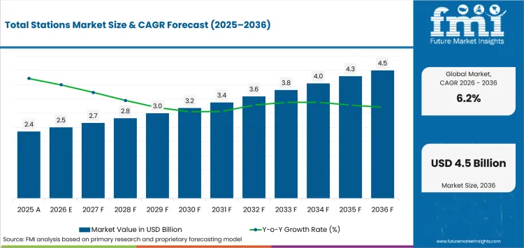
USD 2.5 billion in 2026 and USD 4.5 billion by 2036 at a 6.2% CAGR.
Demand for total stations is projected to expand at a 6.2% CAGR between 2026 and 2036, increasing valuation from USD 2.5 billion in 2026 to USD 4.5 billion by 2036. Surveying workflows increasingly prioritize productivity gains that reduce field labor requirements and speed data transfer between job sites and project teams. Leica Geosystems introduced the TS20 robotic total station in October 2025 with automated target recognition and integrated cloud connectivity. This highlight growing demand for automated measurement systems that enable one-person operation and aiming tasks, supporting direct movement of survey data into digital project workflows.
Australia’s 5.8% CAGR forecast pace exceeds Japan’s 4.7% CAGR as current civil workloads sustain more recurring layout work across active projects. The Australian Bureau of Statistics reported in May 2026 that seasonally adjusted total construction work done rose 3.4% in the March quarter to $83.4 billion, with engineering work 4.7% higher than the same quarter last year. That workload is expected to pull forward rentals and service activity more quickly than markets with longer equipment replacement cycles.
Key Takeaways of Total Stations Market
- Robotic tracking is expected to reduce repeated aiming during layout and control surveys across active project sites with frequent setup changes.
- Based on product type, robotic total stations are projected to account for 31.0% in 2026 due to one-person tracking during repeated layout work.
- In 2026, the 3-5 second segment is expected to lead accuracy with 34.0% share because routine construction tolerances do not require finer angular precision.
- The Bluetooth or Wi-Fi segment is likely to capture 31.0% share in 2026 attributable to direct controller transfer and field-to-office synchronization.
- Operator skill requirements and obstructed sight lines are expected to limit productive use on projects with inconsistent setup practices.
- Active companies include Leica Geosystems AG, Trimble Inc., Topcon Positioning Systems, Inc., South Surveying & Mapping Technology Co., Ltd., GeoMax AG, STONEX Srl, RUIDE Surveying Instrument Co., Ltd. and NIKON-TRIMBLE CO., LTD.
Analyst Perspective
"I would test prism reacquisition and field-to-office handoff before comparing headline angular accuracy on a total station tender. A lower instrument price loses its appeal if local calibration support cannot restore a robotic unit quickly during recurring layout work."
- Nikhil Kaitwade, Principal Consultant, Future Market Insights
How is the Total Stations Market segmented?
The total stations market is segmented by product type, accuracy, connectivity, application, sales channel and region.
The total stations market is segmented by product type, accuracy, connectivity, application, sales channel and region. Product type covers robotic, manual, reflectorless, imaging and scanning instruments, while accuracy spans 3-5 second, 2 second, construction grade and 1 second. Connectivity includes Bluetooth or Wi-Fi, standard data export, radio modem and cellular or cloud links. Applications cover land surveying, construction layout, infrastructure survey, mining or tunneling and monitoring or deformation. Sales channels include survey equipment dealers, direct OEM, rental or leasing and software or hardware bundled routes.
What supports demand for robotic total stations within the product type category?
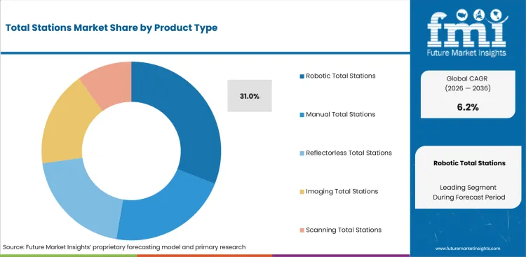
Robotic instruments cut repeated manual aiming during stakeout and control observations on sites with frequent setup changes. RUIDE reported in February 2026 that its upgraded RTS1 algorithm improved prism search and target tracking for one-person surveying.
- By product type, robotic total stations are estimated to hold 31.0% in 2026 owing to lower instrument-side staffing during repeated layout and control work.
- Crews pairing robotic instruments with machine control systems can preserve optical control beside changing design surfaces. That workflow reduces prism reacquisition time during recurring point measurement without removing the need for reliable calibration and local service.
How do construction teams evaluate the 3-5 second accuracy segment?
Construction teams select angular precision that matches routine layout tolerance without paying for finer measurement across every task. Projects using 3D scanning can reserve tighter observations for control networks or verification points that demand smaller angular error during final checks.
- In 2026, the 3-5 second segment is expected to lead accuracy with 34.0% share due to its fit with routine construction tolerances.
- Topcon Corporation launched the SOKKIA SET-M1 series in April 2026 with 1-second to 5-second models and one-person remote observation. Contractors can match instrument precision to field requirements without standardizing every crew on the finest specification.
How does bluetooth or Wi-Fi influence selection within the connectivity category?
Topcon Positioning Systems expanded Hybrid Positioning in October 2025 and introduced a Collage Cloud Connector for synchronized project data. The release connected robotic observations with office systems across active jobs that combine optical measurement and changing design files.
- The Bluetooth or Wi-Fi segment is likely to capture 31.0% share in 2026 attributable to routine controller transfer and field-to-office synchronization.
- Connected geospatial solutions reduce repeated data entry as crews exchange design revisions during active project cycles. Wireless transfer keeps measured coordinates available to office teams without delaying the next scheduled field observation or forcing a separate manual transfer step.
What role does land surveying play within the application category?
Land surveyors use total stations for boundary control and detailed observations in locations that need direct angle-distance measurement. Monument recovery and constrained local geometry preserve optical verification beside land survey equipment that relies on satellite positioning.
- The application category is forecast to be led by land surveying at 31.0% share in 2026 due to recurring cadastral and control measurement.
- The Bureau of Land Management reported in May 2026 that Idaho’s Public Land Survey System spans nearly 54 million acres. Established cadastral frameworks keep traceable control relevant as surveyors recover boundaries without treating the federal acreage figure as proof of the modelled share.
What are the drivers, restraints and opportunities in the Total Stations Market?
Infrastructure work sustains repeated control surveys, but field skill limits productive use as connected software raises the value of finished observations.
- Driver: Civil infrastructure work requires repeated line and grade verification as permanent construction moves from design into staged acceptance.
- Restraint: Robotic labor savings weaken if field crews lack setup and target-recovery skills across changing site conditions.
- Opportunity: Field-to-office software can carry measured coordinates into review systems without repeated entry and support recurring training services.
Civil Infrastructure Work Sustains Repeat Measurement Demand
Civil infrastructure work keeps total station crews returning to the same corridor as line and grade checks move with construction stages. The USA Census Bureau reported in August 2026 that June highway construction spending ran at a USD 150.9 billion seasonally adjusted annual rate. That workload gives construction technology teams recurring optical control tasks instead of a single measurement event at project start.
Training Gaps Limit Robotic Productivity
Robotic instruments reduce instrument-side staffing only if crews can set targets and recover tracking without long field delays. Trimble reported in November 2025 that its Fresno State collaboration supplied S7 robotic total stations plus configuration and on-site training to address the surveyor labor shortage. Survey firms therefore need construction management software and practical training to turn automation into dependable daily output.
Connected Field-to-Office Workflows Expand Software Value
Connected survey workflows raise the commercial value of total stations once measured coordinates move directly into office review and shared project records. GeoMax released X-PAD Service Pack 2/2025 in October 2025 with updates spanning field software plus office processing and cloud services. Firms connecting control observations with building information modeling can sell recurring software support and training around installed instruments.
Which country CAGRs are profiled in the Total Stations Market?
| Country | CAGR |
|---|---|
| Australia | 5.8% |
| United Kingdom | 5.6% |
| United States | 5.4% |
| Germany | 5.0% |
| Japan | 4.7% |
How do country-level CAGRs compare in the Total Stations Market?
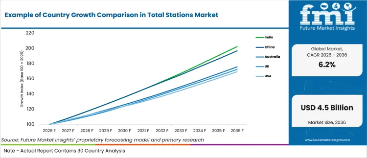
Australia and the United Kingdom form the upper growth group while Germany and Japan form a slower pair, with the United States acting as a transition market. The 1.1-point range is narrow enough that project mix and local service access matter more than headline spacing when manufacturers compare entry conditions.
- Australia’s dispersed infrastructure pipeline favors dealer service around long-distance field mobilization.
- United Kingdom redevelopment preserves optical control work across constrained urban sites.
- Federal highway programs sustain mixed optical and positioning workflows across long corridors.
- Germany’s established instrument fleets extend replacement timing despite recurring civil work.
- Japan combines cadastral modernization with remote-sensing substitution across difficult terrain.
Comparable rates therefore conceal different replacement cycles and service requirements. The full report provides country-level CAGR analysis across North America, Latin America, Europe, East Asia, South Asia, Oceania and the Middle East and Africa.
Country-wise Analysis
- Australia’s long project corridors make local calibration access important because survey crews must move instruments between metro construction sites and regional civil works without losing scheduled control checks during remote project mobilization. In Australia, total station demand is predicted to advance at 5.8% CAGR through 2036 supported by a public works pipeline that keeps layout crews active across transport and utility projects. Infrastructure Australia reported in November 2025 that its five-year Major Public Infrastructure Pipeline had grown 14% from the prior outlook and geospatial analytics teams still face long travel distances that can delay instrument service during peak workload periods.
- United Kingdom survey firms work across dense redevelopment sites and rely on rental access plus fast dealer support during uneven contractor workloads and short project mobilization windows across cities. The Office for National Statistics reported in January 2026 that total construction output fell 1.1% during the three months to November 2025 which makes flexible fleet access more useful during cyclical workloads. Total station demand in the United Kingdom is forecast to rise at 5.6% CAGR over the forecast period supported by recurring transport and redevelopment surveys although underused equipment between assignments can delay permanent fleet purchases for smaller local firms.
- United States contractors use total stations beside machine positioning systems on long highway corridors that require repeated grade checks tied to established control during staged construction and acceptance work over extended schedules. The United States total stations sector is projected to record 5.4% CAGR during the assessment period supported by long-duration highway programs that keep optical verification relevant beside digital construction workflows. The Federal Highway Administration reported in June 2026 that federal highway programs receive about USD 350 billion across fiscal years 2022 to 2026 and local training capacity still determines how quickly robotic instruments become dependable daily field tools.
- Germany’s established instrument fleets make replacement decisions sensitive to service life because civil engineering teams can keep proven total stations until connected workflows and IoT in construction records justify new hardware spending. Total station sales in Germany are forecast to expand at 5.0% CAGR by 2036, shaped by recurring civil work and a mature installed base that slows replacement compared with new fleet purchases. The German Federal Statistical Office reported in June 2026 that civil engineering order stock excluding roads was 14.8% higher year over year in fourth-quarter 2025 and calibration support remains important for converting that workload into replacement orders.
- Japan’s cadastral program mixes optical field control with remote sensing across mountainous areas as survey methods vary by terrain and municipal workflow instead of relying on one instrument route for every boundary assignment. The Ministry of Land Infrastructure Transport and Tourism reported in June 2026 that 594 square kilometers of cadastral area were clarified during fiscal 2025 and remote sensing expanded across forested land. Japan’s total stations outlook is anticipated to advance at 4.7% CAGR over the assessment period influenced by boundary work while optical instrument orders depend on local service coverage and the share of assignments that still require direct line-of-sight observations.
Who are the notable companies in the Total Stations Market?
Leica Geosystems AG, Trimble Inc., Topcon Positioning Systems, Inc., South Surveying & Mapping Technology Co., Ltd., GeoMax AG, STONEX Srl, RUIDE Surveying Instrument Co., Ltd. and NIKON-TRIMBLE CO., LTD. are the notable companies serving this market.
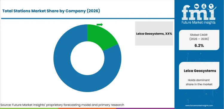
Global geospatial groups compete with regional survey-instrument specialists on tracking reliability plus field software and local calibration support. Contractors comparing optical control with LiDAR mapping also test dealer response before standardizing fleet purchases across several project types. Smaller brands can match core measurements but lose larger programs if local service cannot restore robotic instruments quickly after field damage.
- Leica Geosystems AG, Trimble Inc., Topcon Positioning Systems, Inc. and NIKON-TRIMBLE CO., LTD. combine total station hardware with connected field or office software.
- South Surveying & Mapping Technology Co., Ltd., GeoMax AG, STONEX Srl and RUIDE Surveying Instrument Co., Ltd. compete with broad survey-instrument portfolios and dealer-supported workflows.
Competitive Benchmarking: Total Stations Market
| Company | Robotic Breadth | Workflow Connectivity | Application Coverage | Geographic Reach |
|---|---|---|---|---|
| Leica Geosystems AG | High | High | High | Global |
| Trimble Inc. | High | High | High | Global |
| Topcon Positioning Systems, Inc. | High | High | High | Global |
| South Surveying & Mapping Technology Co., Ltd. | High | Medium | High | Global |
| GeoMax AG | Medium | High | Medium | International |
| STONEX Srl | High | High | High | International |
| RUIDE Surveying Instrument Co., Ltd. | High | Medium | High | International |
| NIKON-TRIMBLE CO., LTD. | High | High | High | Japan |
Key Developments in the Total Stations Market
- In November 2025, South Surveying & Mapping Technology Co., Ltd. launched N2 and N2H total stations plus an updated robotic TS-GNSS solution for one-person optical and satellite positioning.
- In November 2025, Trimble Inc. introduced Mine Insights with Trimble SX12 point clouds supporting future blast-pattern design and reuse of field survey data during mine planning.
- In May 2025, NIKON-TRIMBLE CO., LTD. began domestic sales of Point Cloud View for sharing point clouds and 3D design files including measurements from Trimble SX instruments.
Key Players in the Total Stations Market
Robotic Geospatial Platforms
- Leica Geosystems AG
- Trimble Inc.
- Topcon Positioning Systems, Inc.
Survey Instrument Platforms
- South Surveying & Mapping Technology Co., Ltd.
- STONEX Srl
- RUIDE Surveying Instrument Co., Ltd.
Connected Survey Systems
- GeoMax AG
- NIKON-TRIMBLE CO., LTD.
Total Stations Market - Report Scope
| Coverage field | Report scope |
|---|---|
| Market breakdown | By product type, accuracy, connectivity, application, sales channel and region. |
| Quantitative Units | Revenue in USD billion and CAGR in %. |
| Market Definition | Commercial total stations used for angle and distance measurement with onboard calculation across surveying and construction workflows including mining and deformation monitoring. |
| Regions Covered | North America, Latin America, Europe, East Asia, South Asia and Pacific, and Middle East and Africa. |
| Countries Covered | Australia, United Kingdom, United States, Germany, Japan, and 20+ countries included in the full report. |
| Key Companies Profiled | Leica Geosystems AG, Trimble Inc., Topcon Positioning Systems, Inc., South Surveying & Mapping Technology Co., Ltd., GeoMax AG, STONEX Srl, RUIDE Surveying Instrument Co., Ltd., NIKON-TRIMBLE CO., LTD. |
| Forecast Period | 2026 to 2036. |
| Approach | Primary and secondary research with market triangulation. |
Total Stations Market - Research Methodology
| Method | Approach |
|---|---|
| Primary Research | FMI analysts gathered input from manufacturers, service providers, technology developers, distributors, end users, procurement teams, and subject-matter experts. Interviews examined purchasing decisions, product or service evaluation, adoption barriers, approval requirements, pricing considerations, and expectations for technical or commercial support. Respondents were also asked what evidence is required before a trial, pilot, or initial order develops into regular purchasing. |
| Desk Research | Desk research covered government statistics, regulatory publications, trade data, industry associations, technical literature, standards, company filings, product information, and official corporate announcements. Sources were reviewed for relevance, publication date, geographic coverage, and consistency with the defined market scope. Claims relating to performance, applications, approvals, capacity, investment, and commercial activity were retained only when supported by credible public evidence. |
| Market Sizing and Forecasting | The market model combined the baseline value with historical performance, segment structure, pricing and volume indicators, adoption levels, company participation, and country-level demand conditions. Forecast assumptions considered economic activity, investment trends, regulatory developments, technology adoption, purchasing cycles, supply availability, and barriers to wider market use. Segment and regional estimates were reconciled before the final market total was calculated. |
| Data Validation | Estimates were checked against multiple independent indicators, including public data, company activity, trade patterns, industry developments, and findings from primary interviews. Validation also tested whether products, services, applications, and company revenues fell within the defined market boundaries. Adjacent categories, unsupported claims, overlapping revenues, and activities without direct market relevance were excluded to reduce double counting and maintain consistency across segments and countries. |
Total Stations Market by Segments
Total Stations Market segmented by Product Type:
- Robotic Total Stations
- Manual Total Stations
- Reflectorless Total Stations
- Imaging Total Stations
- Scanning Total Stations
Total Stations Market segmented by Accuracy:
- 3-5 Second
- 2 Second
- Construction Grade
- 1 Second
Total Stations Market segmented by Connectivity:
- Bluetooth or Wi-Fi
- Standard Data Export
- Radio Modem
- Cellular or Cloud
Total Stations Market segmented by Application:
- Land Surveying
- Construction Layout
- Infrastructure Survey
- Mining or Tunneling
- Monitoring or Deformation
Total Stations Market segmented by Sales Channel:
- Survey Equipment Dealers
- Direct OEM
- Rental or Leasing
- Software or Hardware Bundled
Total Stations Market by Region
- North America
- United States
- Canada
- Latin America
- Brazil
- Mexico
- Chile
- Rest of Latin America
- Western Europe
- Germany
- United Kingdom
- Italy
- Spain
- France
- Nordics
- Benelux
- Rest of Western Europe
- Eastern Europe
- Russia
- Poland
- Hungary
- Balkan and Baltic States
- Rest of Eastern Europe
- East Asia
- China
- Japan
- South Korea
- South Asia and Pacific
- India
- ASEAN
- Australia and New Zealand
- Rest of South Asia and Pacific
- Middle East and Africa
- Kingdom of Saudi Arabia
- Other GCC Countries
- Türkiye
- South Africa
- Other African Union Countries
- Rest of Middle East and Africa
Research Sources and Bibliography
- Leica Geosystems AG. (2025, October 2). Introducing the Leica TS20 robotic total station with edge AI: Elevating everyday productivity even in the toughest conditions.
- Australian Bureau of Statistics. (2026, May 27). Construction Work Done, Australia, Preliminary.
- RUIDE Surveying Instrument Co., Ltd. (2026, February 25). Meet the Upgraded Robotic Total Station RTS1.
- Topcon Corporation. (2026, April 8).
- Topcon Positioning Systems, Inc. (2025, October 7). Topcon launches latest Geomatics innovations at INTERGEO 2025 for simplified, connected mass data workflows.
- Bureau of Land Management. (2026, May 5). A Point That Put Idaho on the Map: Celebrating the Boise Meridian Initial Point.
- USA Census Bureau. (2026, August 3). Monthly Construction Spending, June 2026.
- Trimble Inc. (2025, November 6). Trimble, California Surveying & Drafting Supply and Fresno State Collaborate to Address Surveyor Labor Shortage.
- GeoMax AG. (2025, October 22). Product Release: New X-PAD Service Pack 2/2025.
- Infrastructure Australia. (2025, November 13). 2025 Infrastructure Market Capacity Report.
- Office for National Statistics. (2026, January 15). Construction output in Great Britain: November 2025.
- Federal Highway Administration. (2026, June 18). Funding.
- German Federal Statistical Office. (2026, June 1). Index of stock of orders for main construction industry, building construction, civil engineering.
- Ministry of Land, Infrastructure, Transport and Tourism. (2026, June 26).
- South Surveying & Mapping Technology Co., Ltd. (2025, November 19). NEWSLETTER 209: THIS MONTH'S UPDATE FOR DISTRIBUTORS.
- Trimble Inc. (2025, November 11). Trimble Unveils Trimble Mine Insights to Deliver AI-Powered Analytics to Optimize Mining Operations.
- STONEX Srl. (n.d.). About us. Retrieved August 9, 2026.
- NIKON-TRIMBLE CO., LTD. (2025, May 27).
- CHC Navigation. (2025, November 14). CHC Navigation Introduces CTS-M100: Cost-Effective Total Station for Streamlined Surveying Workflows.
- Hi-Target Surveying Instrument Co., Ltd. (2025, October 10). Hi-Target Unveils Next-Gen Robotic Total Station at INTERGEO 2025.
- Topcon Corporation. (2025, January 14).
This bibliography is provided for reader reference and is not exhaustive. The full report contains the complete reference list and detailed citations.
This Report Answers
- How large is the Total Stations Market in 2026 and 2036?
- Which operating conditions are expected to support total station demand across commercial survey workflows?
- Which product type is projected to account for 31% of demand in 2026?
- Why does the 3-5 second accuracy range hold the leading share in 2026?
- How does connectivity influence total station selection across field and office workflows?
- How do country growth rates differ across the profiled Total Stations Market?
- Which companies compete across robotic instruments and connected survey workflows?
- What operating constraints can limit wider total station utilization across active project sites?
Frequently Asked Questions
How big is the total stations market in 2026?
The total stations market is estimated at USD 2.5 billion in 2026 and is projected to reach USD 4.5 billion by 2036. Growth is driven by increasing adoption of robotic tracking systems and connected surveying workflows across construction and infrastructure projects.
What is the CAGR of the total stations market from 2026 to 2036?
The total stations market is projected to grow at a CAGR of 6.2% between 2026 and 2036. Expansion is supported by recurring demand for land surveying, construction layout, and precise measurement applications.
Which product type is projected to lead the total stations market?
Robotic total stations are projected to account for 31.0% of the market in 2026. Their leading share is supported by one-person operation capabilities, improved productivity, and reduced manual surveying requirements.
How much is the total stations market expected to add between 2026 and 2036?
The total stations market is expected to add USD 2.0 billion in value between 2026 and 2036. Growth reflects continued investment in surveying equipment and expanding infrastructure development activities.
Which companies are active in the total stations market?
Key companies operating in the market include Leica Geosystems AG, Trimble Inc., Topcon Positioning Systems, Inc., South Surveying & Mapping Technology Co., Ltd., GeoMax AG, STONEX Srl, RUIDE Surveying Instrument Co., Ltd., and NIKON-TRIMBLE CO., LTD. These companies compete through product innovation, robotic surveying capabilities, and integrated digital workflow solutions.
Preview the report firsthand - request a free sample
Get SampleGet the brochure for pricing and purchase details.
Get PDFTable of Content
- Key Takeaways
- Market Size and CAGR
- Top Growth Driver
- Fastest Growing Segment
- Leading Region
- Key Companies
- Emerging Opportunities
- Executive Summary
- Global Market Outlook
- Demand-side Trends
- Supply-side Trends
- Technology Roadmap Analysis
- Analysis and Recommendations
- Analyst Perspective (What is happening? Why now? What should investors know?)
- Key Questions Answered
- How large is the market?
- What is the CAGR?
- What are key trends?
- Which region dominates?
- Who are the leaders?
- Market Overview
- Market Coverage / Taxonomy
- Market Definition / Scope / Limitations
- Research Methodology
- Chapter Orientation
- Analytical Lens and Working Hypotheses
- Market Structure, Signals, and Trend Drivers
- Benchmarking and Cross-market Comparability
- Market Sizing, Forecasting, and Opportunity Mapping
- Research Design and Evidence Framework
- Desk Research Programme (Secondary Evidence)
- Expert Input and Fieldwork (Primary Evidence)
- Tooling, Models, and Reference Databases
- Data Engineering and Model Build
- Quality Assurance and Audit Trail
- Market Background
- Market Dynamics (Drivers, Restraints, Opportunity, Trends)
- Scenario Forecast (Optimistic, Likely, Conservative)
- Impact Analysis
- AI Impact
- Sustainability Impact
- Regulatory Impact
- Technology Impact
- Consumer / Buyer Analysis
- Purchase Drivers
- Adoption Barriers
- Buyer Journey
- Opportunity Map Analysis
- Product Life Cycle Analysis
- Supply Chain Analysis
- Investment Feasibility Matrix
- Value Chain Analysis
- PESTLE and Porter's Analysis
- Regulatory Landscape
- Regional Parent Market Outlook
- Production and Consumption Statistics
- Import and Export Statistics
- Global Market Analysis and Forecast, 2021 to 2036
- Historical Market Size Value (USD Million) Analysis, 2021 to 2025
- Current and Future Market Size Value (USD Million) Projections, 2026 to 2036
- Y-o-Y Growth Trend Analysis
- Absolute $ Opportunity Analysis
- Global Market Pricing Analysis, 2021 to 2036
- Global Market Analysis and Forecast, By Product Type, 2021 to 2036
- Introduction / Key Findings
- Historical Market Size Value (USD Million) Analysis By Product Type, 2021 to 2025
- Current and Future Market Size Value (USD Million) Analysis and Forecast By Product Type, 2026 to 2036
- Robotic Total Stations
- Manual Total Stations
- Reflectorless Total Stations
- Imaging Total Stations
- Scanning Total Stations
- Robotic Total Stations
- Y-o-Y Growth Trend Analysis By Product Type, 2021 to 2025
- Absolute $ Opportunity Analysis By Product Type, 2026 to 2036
- Global Market Analysis and Forecast, By Accuracy, 2021 to 2036
- Introduction / Key Findings
- Historical Market Size Value (USD Million) Analysis By Accuracy, 2021 to 2025
- Current and Future Market Size Value (USD Million) Analysis and Forecast By Accuracy, 2026 to 2036
- 3-5 Second
- 2 Second
- Construction Grade
- 1 Second
- 3-5 Second
- Y-o-Y Growth Trend Analysis By Accuracy, 2021 to 2025
- Absolute $ Opportunity Analysis By Accuracy, 2026 to 2036
- Global Market Analysis and Forecast, By Connectivity, 2021 to 2036
- Introduction / Key Findings
- Historical Market Size Value (USD Million) Analysis By Connectivity, 2021 to 2025
- Current and Future Market Size Value (USD Million) Analysis and Forecast By Connectivity, 2026 to 2036
- Bluetooth or Wi-Fi
- Standard Data Export
- Radio Modem
- Cellular or Cloud
- Bluetooth or Wi-Fi
- Y-o-Y Growth Trend Analysis By Connectivity, 2021 to 2025
- Absolute $ Opportunity Analysis By Connectivity, 2026 to 2036
- Global Market Analysis and Forecast, By Application, 2021 to 2036
- Introduction / Key Findings
- Historical Market Size Value (USD Million) Analysis By Application, 2021 to 2025
- Current and Future Market Size Value (USD Million) Analysis and Forecast By Application, 2026 to 2036
- Land Surveying
- Construction Layout
- Infrastructure Survey
- Mining or Tunneling
- Monitoring or Deformation
- Land Surveying
- Y-o-Y Growth Trend Analysis By Application, 2021 to 2025
- Absolute $ Opportunity Analysis By Application, 2026 to 2036
- Global Market Analysis and Forecast, By Sales Channel, 2021 to 2036
- Introduction / Key Findings
- Historical Market Size Value (USD Million) Analysis By Sales Channel, 2021 to 2025
- Current and Future Market Size Value (USD Million) Analysis and Forecast By Sales Channel, 2026 to 2036
- Survey Equipment Dealers
- Direct OEM
- Rental or Leasing
- Software or Hardware Bundled
- Survey Equipment Dealers
- Y-o-Y Growth Trend Analysis By Sales Channel, 2021 to 2025
- Absolute $ Opportunity Analysis By Sales Channel, 2026 to 2036
- Global Market Analysis and Forecast, By Region, 2021 to 2036
- Introduction
- Historical Market Size Value (USD Million) Analysis By Region, 2021 to 2025
- Current Market Size Value (USD Million) Analysis and Forecast By Region, 2026 to 2036
- North America
- Latin America
- Western Europe
- Eastern Europe
- East Asia
- South Asia and Pacific
- Middle East & Africa
- Market Attractiveness Analysis By Region
- North America Market Analysis and Forecast, By Country, 2021 to 2036
- Historical Market Size Value (USD Million) Trend Analysis By Market Taxonomy, 2021 to 2025
- Market Size Value (USD Million) Forecast By Market Taxonomy, 2026 to 2036
- By Country
- USA
- Canada
- By Product Type
- By Accuracy
- By Connectivity
- By Application
- By Sales Channel
- By Country
- Market Attractiveness Analysis
- By Country
- By Product Type
- By Accuracy
- By Connectivity
- By Application
- By Sales Channel
- Key Takeaways
- Latin America Market Analysis and Forecast, By Country
- Historical Market Size Value (USD Million) Trend Analysis By Market Taxonomy, 2021 to 2025
- Market Size Value (USD Million) Forecast By Market Taxonomy, 2026 to 2036
- By Country
- Brazil
- Mexico
- Chile
- Rest of Latin America
- By Product Type
- By Accuracy
- By Connectivity
- By Application
- By Sales Channel
- By Country
- Market Attractiveness Analysis
- By Country
- By Product Type
- By Accuracy
- By Connectivity
- By Application
- By Sales Channel
- Key Takeaways
- Western Europe Market Analysis and Forecast, By Country
- Historical Market Size Value (USD Million) Trend Analysis By Market Taxonomy, 2021 to 2025
- Market Size Value (USD Million) Forecast By Market Taxonomy, 2026 to 2036
- By Country
- Germany
- UK
- Italy
- Spain
- France
- Nordic
- BENELUX
- Rest of Western Europe
- By Product Type
- By Accuracy
- By Connectivity
- By Application
- By Sales Channel
- By Country
- Market Attractiveness Analysis
- By Country
- By Product Type
- By Accuracy
- By Connectivity
- By Application
- By Sales Channel
- Key Takeaways
- Eastern Europe Market Analysis and Forecast, By Country
- Historical Market Size Value (USD Million) Trend Analysis By Market Taxonomy, 2021 to 2025
- Market Size Value (USD Million) Forecast By Market Taxonomy, 2026 to 2036
- By Country
- Russia
- Poland
- Hungary
- Balkan & Baltic
- Rest of Eastern Europe
- By Product Type
- By Accuracy
- By Connectivity
- By Application
- By Sales Channel
- By Country
- Market Attractiveness Analysis
- By Country
- By Product Type
- By Accuracy
- By Connectivity
- By Application
- By Sales Channel
- Key Takeaways
- East Asia Market Analysis and Forecast, By Country
- Historical Market Size Value (USD Million) Trend Analysis By Market Taxonomy, 2021 to 2025
- Market Size Value (USD Million) Forecast By Market Taxonomy, 2026 to 2036
- By Country
- China
- Japan
- South Korea
- By Product Type
- By Accuracy
- By Connectivity
- By Application
- By Sales Channel
- By Country
- Market Attractiveness Analysis
- By Country
- By Product Type
- By Accuracy
- By Connectivity
- By Application
- By Sales Channel
- Key Takeaways
- South Asia and Pacific Market Analysis and Forecast, By Country
- Historical Market Size Value (USD Million) Trend Analysis By Market Taxonomy, 2021 to 2025
- Market Size Value (USD Million) Forecast By Market Taxonomy, 2026 to 2036
- By Country
- India
- ASEAN
- Australia & New Zealand
- Rest of South Asia and Pacific
- By Product Type
- By Accuracy
- By Connectivity
- By Application
- By Sales Channel
- By Country
- Market Attractiveness Analysis
- By Country
- By Product Type
- By Accuracy
- By Connectivity
- By Application
- By Sales Channel
- Key Takeaways
- Middle East & Africa Market Analysis and Forecast, By Country
- Historical Market Size Value (USD Million) Trend Analysis By Market Taxonomy, 2021 to 2025
- Market Size Value (USD Million) Forecast By Market Taxonomy, 2026 to 2036
- By Country
- Kingdom of Saudi Arabia
- Other GCC Countries
- Türkiye
- South Africa
- Other African Union
- Rest of Middle East & Africa
- By Product Type
- By Accuracy
- By Connectivity
- By Application
- By Sales Channel
- By Country
- Market Attractiveness Analysis
- By Country
- By Product Type
- By Accuracy
- By Connectivity
- By Application
- By Sales Channel
- Key Takeaways
- Key Countries Market Analysis
- USA
- Pricing Analysis
- Market Share Analysis, 2025
- By Product Type
- By Accuracy
- By Connectivity
- By Application
- By Sales Channel
- Canada
- Pricing Analysis
- Market Share Analysis, 2025
- By Product Type
- By Accuracy
- By Connectivity
- By Application
- By Sales Channel
- Mexico
- Pricing Analysis
- Market Share Analysis, 2025
- By Product Type
- By Accuracy
- By Connectivity
- By Application
- By Sales Channel
- Brazil
- Pricing Analysis
- Market Share Analysis, 2025
- By Product Type
- By Accuracy
- By Connectivity
- By Application
- By Sales Channel
- Chile
- Pricing Analysis
- Market Share Analysis, 2025
- By Product Type
- By Accuracy
- By Connectivity
- By Application
- By Sales Channel
- Germany
- Pricing Analysis
- Market Share Analysis, 2025
- By Product Type
- By Accuracy
- By Connectivity
- By Application
- By Sales Channel
- UK
- Pricing Analysis
- Market Share Analysis, 2025
- By Product Type
- By Accuracy
- By Connectivity
- By Application
- By Sales Channel
- Italy
- Pricing Analysis
- Market Share Analysis, 2025
- By Product Type
- By Accuracy
- By Connectivity
- By Application
- By Sales Channel
- Spain
- Pricing Analysis
- Market Share Analysis, 2025
- By Product Type
- By Accuracy
- By Connectivity
- By Application
- By Sales Channel
- France
- Pricing Analysis
- Market Share Analysis, 2025
- By Product Type
- By Accuracy
- By Connectivity
- By Application
- By Sales Channel
- India
- Pricing Analysis
- Market Share Analysis, 2025
- By Product Type
- By Accuracy
- By Connectivity
- By Application
- By Sales Channel
- ASEAN
- Pricing Analysis
- Market Share Analysis, 2025
- By Product Type
- By Accuracy
- By Connectivity
- By Application
- By Sales Channel
- Australia & New Zealand
- Pricing Analysis
- Market Share Analysis, 2025
- By Product Type
- By Accuracy
- By Connectivity
- By Application
- By Sales Channel
- China
- Pricing Analysis
- Market Share Analysis, 2025
- By Product Type
- By Accuracy
- By Connectivity
- By Application
- By Sales Channel
- Japan
- Pricing Analysis
- Market Share Analysis, 2025
- By Product Type
- By Accuracy
- By Connectivity
- By Application
- By Sales Channel
- South Korea
- Pricing Analysis
- Market Share Analysis, 2025
- By Product Type
- By Accuracy
- By Connectivity
- By Application
- By Sales Channel
- Russia
- Pricing Analysis
- Market Share Analysis, 2025
- By Product Type
- By Accuracy
- By Connectivity
- By Application
- By Sales Channel
- Poland
- Pricing Analysis
- Market Share Analysis, 2025
- By Product Type
- By Accuracy
- By Connectivity
- By Application
- By Sales Channel
- Hungary
- Pricing Analysis
- Market Share Analysis, 2025
- By Product Type
- By Accuracy
- By Connectivity
- By Application
- By Sales Channel
- Kingdom of Saudi Arabia
- Pricing Analysis
- Market Share Analysis, 2025
- By Product Type
- By Accuracy
- By Connectivity
- By Application
- By Sales Channel
- Türkiye
- Pricing Analysis
- Market Share Analysis, 2025
- By Product Type
- By Accuracy
- By Connectivity
- By Application
- By Sales Channel
- South Africa
- Pricing Analysis
- Market Share Analysis, 2025
- By Product Type
- By Accuracy
- By Connectivity
- By Application
- By Sales Channel
- USA
- Market Structure Analysis
- Competition Dashboard
- Competition Benchmarking
- Market Share Analysis of Top Players
- By Regional
- By Product Type
- By Accuracy
- By Connectivity
- By Application
- By Sales Channel
- Emerging Startups
- Innovation Benchmarking
- Competition Analysis
- Competition Deep Dive
- Leica Geosystems
- Overview
- Product Portfolio
- Profitability by Market Segments
- Sales Footprint
- Strategy Overview
- Marketing Strategy
- Product Strategy
- Channel Strategy
- Trimble
- Topcon Positioning
- Sokkia
- South Surveying
- Hi-Target
- Nikon-Trimble
- GeoMax
- Stonex
- Ruide Surveying
- Leica Geosystems
- Case Studies
- Success Stories
- Recent Developments
- Competition Deep Dive
- Assumptions & Acronyms Used